Home| Meetings | Membership | Links| Contact
Australian Canals
One frequently asked question is “Are there any canals in Australia?” The answer is “Yes”! Although the focus of most of the ACS meetings is on overseas canals and inland waterways, we do have some Australian canals but they are not suitable for cruising holidays. For more information about Australian Inland Waterways please click on to that section on our title page.
Brief information about some of Australia’s transport canals is set out below. This page includes sections about canals in New South Wales, Victoria, and Tasmania.
New South Wales
Berry’s Canal - Australia’s first transport canal
In June 1822, Alexander Berry sailed his 15 tonne cutter Blanche from Sydney 150 kms down the south coast to the Shoalhaven loaded with tools and provisions. Hamilton Hume, who later became a well-known explorer, was also on board. On 21st June, 1822, the entrance to Shoalhaven Heads appeared dangerous and four men volunteered to test it in the cutter’s boat. The boat capsized drowning two of the men. Berry then sailed up the Crookhaven River but was stopped by a sand spit. Undaunted, the crew hauled the Blanche across the spit.
Four days later Hamilton Hume was left with three men at the isthmus to cut a passage using only hand tools. The canal, which was 191 m long, was completed in 12 days. This was the first transport canal to be cut in Australia. The river has since cut the passage wider and deeper to its present dimensions, making it now the real entrance to the Shoalhaven River.

Berry's Canal
The Alexandra Canal
The 3.9 km long Alexandra Canal is one of the main tributaries of the Cooks River, joining it near the Sydney Airport.
The original Shea’s Creek was a narrow, winding partially tidal creek. From the mid 1800’s, wool washes, tanneries and chemical manufacturers discharged their effluent into the creek. From the 1880’s intensive development began with quarries, brickworks and factories replacing the previous dairy farming and residential land uses.
Between 1887 and 1900, Shea’s Creek was excavated to form the Alexandra Canal. It was named in honour of Princess Alexandra. It is a rare example of a 19th century canal construction, being one of only two navigable channels built in New South Wales. Its construction by unemployed relief workers during the 1890’s depression was an impressive achievement taking over a decade to complete.
During excavation of the canal, dugong bones, aboriginal axes and the remains of an ancient forest below the low tide level were discovered. These findings have helped scientific understanding of sea level changes along the eastern seaboard and the antiquity of aboriginal presence in the Sydney area.
The canal provided a transport link to industries along its length and a source for water extraction for industrial purposes. The navigable waterway was planned to extend through to Sydney Harbour but this was not achieved and the only further works on the canal involved the diversion of the lower section to allow for the expansion of Sydney Airport.
Currently the vision for the Alexandra Canal is to become a major recreational, ecological and visual water asset within a regional green corridor system linking the Cooks River with Sydney, Moore and Anzac Parade Parks. Top

Learning about the Alexandra Canal
Hawthorne Canal
After much discussion in the 1890’s regarding the canalising of Long Cove Creek at Haberfield, an inner western suburb of Sydney, a navigable canal from the Parramatta River to Marion Street, Haberfield was opened. A commuter ferry service began in 1903 with numerous ferries leaving the Haberfield Wharf daily for the city. However, this ferry service was soon abandoned due to the sedimentation of the canal and competition from nearby tram services.
North Creek Canal, Ballina, NSW
The North Creek Canal is located at Ballina on the Far North Coast of New South Wales, about 750 km north of Sydney. The canal is about 3.5 km in length, and was constructed in the late nineteenth century to provide a safe and reliable route for the transport of sugar cane.
The cultivation of sugar cane in the Richmond River area started in the mid-19th century, and became a significant factor in the economy of the area. A substantial mill was in operation at Broadwater in the 1880s.
In the 1800s transport of cane to the mills was predominantly by water. Barges carrying cane from the areas north of Ballina travelled via North Creek to the junction with the Richmond River (located about one kilometre from the river mouth), and thence along the Richmond River to Broadwater. The channels near the junction were unstable, and navigation through the area was at times very difficult, due to shifting sandbanks and strong wave action. This frequently disrupted the transport of cane.
Fishery Creek joined the Richmond River at a point about three kilometres upstream of the junction with North Creek. This creek formed the basis of the Canal. The canal was completed in late 1896 by the NSW Department of Public Works. The Canal was lock-free with a channel width of 19 m and depth of about 2.4 m at low tide. Cane was transported through the canal on wooden barges towed by small tugs. The transport of cane by water generally declined progressively throughout the 20th century.
Today the canal appears to be in reasonably good condition. The canal banks are reasonably accessible to walkers. There is no towpath. Road signs on the Pacific Highway show in one place Fishery Creek and in another, The Canal.
(Information provided by Brian and Naelo Jenkins) Top

North Creek Canal
Victoria
Sale Canal
The longest true canal in Australia is the Sale Canal in Victoria which is about 5 km long. It was dug in the period 1886-1890 to connect the town of Sale with Gippsland Lakes and thence to Bass Strait. Sale is approx. 200 kms east of Melbourne.

Sale Canal
Coode Canal
The Coode Canal in Victoria was opened on 11th August 1886. It was 1 800 m long and 100 m wide. It was a visionary feat of engineering under the direction of Sir John Coode. It not only shortened the travel time for ships up the Yarra River but it also created Victoria Harbour and Victoria Dock.Top
Tasmania
ACS acknowledges the information provided by Ben Storer and Robert Stevenson in preparing this section.Denison Canal
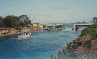
This Tasmanian canal is a cut through the isthmus of the Forestier Peninsula at Dunalley in southern Tasmania, on the route between Hobart and Port Arthur. It shortens the sea journey from the east coast to Hobart by about 80 km. Proposals for cutting a canal through East Bay Neck appear as early as 1820 amongst the settlers, fishermen and traders who regularly travelled between the East Coast and Hobart. Though many recognised the benefits of a canal at this location, little serious consideration was given to a canal until William Denison became Governor in 1847.
His work on the Rideau Canal in Canada was likely to have fostered his enthusiasm for building canals in Tasmania. A surveyor was dispatched to East Bay Neck but the initial enthusiasm for the canal waned once Governor Denison left Tasmania in 1855. The canal was finally opened in 1905. Its dimensions were 2.4km long, 3m deep at low tide and 17m wide (no locks).
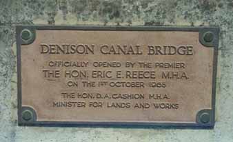
The first swing bridge was built in the Launceston Railway Workshops. The roller bearing can be seen today mounted outside a nearby hotel. A new concrete bridge working with a hydraulic system replaced this in 1965. Top


Denison canal: Plaque, and the canal itself
Egg Island Canal
The towns of Franklin and Cradoc are on opposite banks of the Huon River. In between these two centres, situated midstream, are the North and South Egg Islands. The location of the islands made water travel between the two centres difficult.
In order to facilitate better navigation between the towns, convict labour was used to cut a canal through South Egg Island in 1838. At some point in the subsequent years the canal became impassable so a second canal was cut across North Egg Island in the 1870’s. This canal was 3m wide and 1.2m deep, but it soon followed the footsteps of its southern counterpart silting up and becoming un-navigable.
In 1884, work began on re-excavating the original canal on South Egg Island. A team of horses dragging a dredge was used to make the cutting. The canal was enlarged by H. E. Clark to 6m wide and 0.6m below the waterline. The Government paid 364 pounds for this work. This canal is still in use today.
In 2013, the Egg Is Canal was listed on the Tasmanian Heritage Register after a campaign by local residents, supported by the ACS.

Egg Island Canal in 1920
The unsuccessful Ralph’s Bay Neck Canal (Lauderdale Canal)
The first suggestion of cutting a canal through the isthmus at Ralph’s Bay Neck was made by local landowners in the early 19th century. There was apparently no further discussion of a canal until Governor William Denison suggested in 1854 that a cana be cut at Ralph’s Bay Neck to act as ancillary to the canal he proposed for East Bay Neck (Denison Canal). However, no action was taken.Despite various petitions for the construction of a canal, the project was finally abandoned in 1927. Ralph’s Bay Neck Canal today remains unfinished, a testament to Governor Denison’s 1854 vision, plied only by the miniature yachts of the local model boat club.
Three other unsuccessful Tasmanian canals were proposed. These were the Eagle Hawk Neck, the Derwent and the Cygnet Canal proposals.
Does anyone know of any other transport canals in Australia? We’d like to hear from you if you do. Please contact us.
